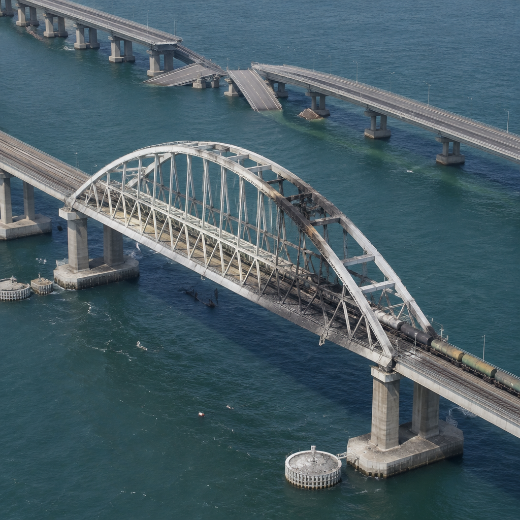
“A section of the northern highway bridge, measuring approximately 225 meters [approximately 738 feet], has collapsed with some sections remaining partially submerged,” Vantor told TWZ after reviewing satellite imagery taken on November 19, 2026.
Vantor's WorldView-1 imagery and what it shows
Vantor’s WorldView‑1 satellite captured the scene at 1:51 PM local time on November 19, 2026. The image shows the previously destroyed section of the road span and new damage to the rail span, with at least two — and possibly three — impact points visible on the rail portion to the left of the arch. A large scorch mark appears on one corner of an arch that crosses part of the rail span; Vantor and TWZ note that this scorch mark does not appear new when compared with imagery and surface-level pictures and video from the November 16–17 strikes.
Rail span versus road span: nature and extent of the damage
The satellite picture indicates the rail damage is concentrated on one of the two sets of tracks, consistent with reports that rail service has been restored but only on a single line. TWZ reports that the rail line was hit again overnight, temporarily halting train traffic across the Kerch Bridge. Observers point out that the rail section is built to carry much heavier, denser loads than the road portion, and that difference is visible in the contrasting construction of the arches over the rail and road spans. The road span’s central shipping‑channel section collapsed into the strait during the earlier attack on the night of November 16–17; Vantor estimates the collapsed span to be over 270 meters in length and places the arch’s weight at roughly 5,500–6,000 tons.

Audit-ready is a season. It shouldn't be.
Evidence in spreadsheets, controls drifting between audits, frameworks multiplying on flat headcount. Nubivance runs continuous compliance on Rapid7 Cyber GRC - SOC 2, HIPAA, ISO 27001, PCI, CMMC.
End the scrambleImpact on shipping and Russian logistics through the Kerch Strait
Vantor reported no repair efforts visible on or near the damaged bridge and observed no shipping traffic in the strait when the image was taken. Ukrainian and maritime sources note the collapsed road sections fell into the narrow deep‑water passage used by large vessels: the Kerch‑Yenikalsky Canal, roughly 120 meters wide, runs under the bridge’s central arch. The Kerch Strait is only 3–6 meters deep outside that channel, so large‑tonnage traffic between the Black and Azov Seas must use the canal; debris now lies in that channel, and clearing it will require specialized equipment and complex underwater work.
Beyond sea routes, the Kerch crossing is one link in overland logistics. With the bridge damaged, the remaining options for moving ammunition, fuel, food, and other supplies to Russian forces in Ukraine are ferries across the Kerch Strait or much longer overland routes around the Sea of Azov. TWZ cites earlier reporting that Ukraine’s mid‑range strike drone campaign has placed land routes under intense fire and that Kyiv has been striking Russian shipping in the Sea of Azov — actions that, when combined with the bridge damage, are forcing reliance on longer, riskier routes.
How Ukrainian forces, Russian authorities, and Crimean residents are responding
- Ukrainian military and government: Ukraine claimed it struck the railway section with a volley of Neptune cruise missiles the night before the Vantor image; the Ukrainian MoD said the Kerch crossing is one link in an effort to reduce Russia’s military logistics, and a source in the Ukrainian president’s office told TWZ they were still “checking how badly” the railway tracks were damaged.
- Russian authorities and repair planning: Russian Deputy Prime Minister Marat Khusnullin told TASS officials would determine a timeline for restoring the bridge within a week, while Russian President Vladimir Putin, speaking in Shenzhen at the APEC forum, pledged that Russia “will respond” and warned the response “will be much more painful.” TWZ notes rebuilding would likely be lengthy and expensive even under optimal conditions: the road span originally took more than two years to build and the rail portion even longer.
- Local civilian measures: Officials on the peninsula plan to launch free passenger boat service on November 20 between Port Krym (Kerch) and Port Kavkaz (Taman). Oleg Kryuchkov, an adviser to the Russian‑installed head of Crimea, said private vehicles will not be carried and passengers may not transport gasoline in canisters; he also warned crossings would depend on weather and could be suspended for storms or strong winds. TWZ published social media video showing Crimean residents lining up for gasoline after the bridge strikes.
Wider strike campaign and damaged links beyond Kerch
TWZ cites the Ukrainian United24 outlet reporting that since October Ukrainian forces struck at least six bridges along the R‑280 highway, a major logistics corridor through occupied areas on the western shore of the Sea of Azov. The Ukrainian outlet and the MoD say damage has been confirmed to road surfaces of three more bridges in mid‑November: across the Seversky Donets River in the Pryshyb area (Luhansk region) and across the Mius River in the Taganrog area (Rostov region) on November 15, and across the Mius Lagoon in Lakedemonovka (Rostov region) on November 14.
The Vantor image, the pattern of repeated strikes, and the visible collapse of the road span into the main shipping channel collectively portray a logistics problem with multiple choke points rather than a single isolated loss. Clearing the central channel and rebuilding damaged spans will be a complex, resource‑intensive task — and, as the parties themselves acknowledge, both repair work and military responses will unfold under the ongoing threat of further strikes.
Source: TWZ — Impacts Of Latest Neptune Missile Strike On Kerch Bridge Seen In Satellite Imagery